I was thinking of returning to Norvin Green State Forest to explore the northern part, but when I drove to the area designated as a parking area on the NY-NJ Trail Conference map, I didn’t find an obvious spot. I have had that problem with the map previously: if it’s not an obvious parking lot, and if there are no other cars there, I won’t feel comfortable parking there.
There was another parking area that I could use to access the trails I wanted, but I had forgotten to take coordinates with me for my GPS, and driving by I didn’t find the road that I needed to take. So I instead went to Ringwood State Park, where I’ve never been before. Owing to a late start, and my missteps in first trying to go to Norvin Green, I was off to a very late start.
12:30 p.m.: I parked in the northern parking lot at Ringwood Manor, which was right next to the Ringwood River, where some families were wading. I crossed two wooden pedestrian bridges across the river.

Ringwood River
After about 100′ the white-blazed trail led me to Sloatsburg Road, which I carefully crossed. A red-blazed trail starts here, and I wanted to take that one to the east, but didn’t see the blazes immediately and instead continued on the white-blazed trail to the south. I met a mountain biker going in the opposite direction, and stepped aside to let him pass. I later saw a sign that the white-blazed trail was only for hikers, whereas the yellow-blazed trail was available to hikers, bicyclists and equestrians. So I guess the mountain biker was on the wrong trail.
About 0.5 miles into the hike, the white-blazed trail came to an intersection that did not appear to be blazed. I continued on, but after 100′ came to Morris Road, which I did not expect from my map. I realized that by continuing straight at the intersection, I had turned onto the yellow-blazed trail.
12:56 p.m.: I backtracked and took the side trail northeast, and saw that white (and yellow) blazes were hidden behind a tree branch.

Blazes
The trails soon diverged again, and I turned east on the white trail.

White trail
This again joined Morris Road, but now at a place where I expected it to be.
1:08 p.m.: About a mile from my car, Morris Road crossed Cupsaw Brook:

Cupsaw Brook
1:27 p.m.: After about 0.1 miles on Morris Road, white blazes again led me into the woods, where I stopped for lunch on top of this boulder, and called my Mom to wish her a happy Mother’s Day:

Boulder
Interesting tree(s):

Tree
1:50 p.m.: After another 0.5 miles, the trail again popped out of the woods at the entrance to the New Jersey State Botanical Garden. The map shows that the white trail was supposed to reenter the woods on a woods road, but I didn’t see any blazes and instead walked south along the access road of the botanical garden.

Eagle sculpture
1:58 p.m.: I had to stand here at least 5 minutes to take shots that didn’t have people in them, as people constantly drove and walked back and forth through this area. For several minutes, a car stopped there and a woman got out, blocking my view while she argued in Russian to the driver and other passengers. Finally, everyone cleared out long enough for me to take overexposed and underexposed photos, which I later turned into this HDR shot:

New Jersey State Botanical Garden
2:15 p.m.: After another 0.8 miles, I finally reached the end of the access road through the botanical gardens and followed another woods road east back to the white trail, which was continuing to the south.

White trail
I soon left the white trail, again following a woods road northeast to its intersection with the red-blazed trail. I followed this to the northeast. This trail circled around “Thunder Mountain Shooting Range,” so I unfortunately got to hear people shooting the entire time I hiked. I also didn’t find any scenic views on this trail; the map showed a couple from Mount Defiance, but either I missed them or I didn’t find it to be too scenic. Oh, it was also around 80 degrees, and I wished it had been cooler.
2:31 p.m.: A fallen tree with some nice texture:

Fallen tree
2:34 p.m.: At least I appreciated being on a footpath instead of a woods road:

Red trail
2:48 p.m.: A ground level shot through the grass:

Tall grass
There were a few spots with bare rock:

Bare rock
2:56 p.m.: I rarely see animals when I hike. The most common are chipmunks and squirrels, and they typically flee out of sight when they hear me/see me. Here I heard something that sounded a little larger than the typical squirrel (though they can make a racket nosing through dead leaves), and I saw a turkey head pop above the hill. They were a pair, and I tried sneaking up on them, but even though they were at least 50′ away, they didn’t want to remain within sight of me. Thus, this poor shot is all that I got. I had my telephoto lens on, but just barely got this shot off at 45mm (90mm equivalent). By the time I thought about zooming up to 200mm, the turkeys were gone.

Turkey
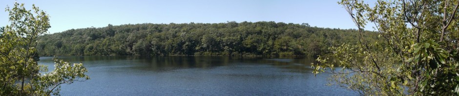
3:44 p.m.: The red trail curved a bit to the northwest, and about 2.4 miles after leaving the botanical gardens, I arrived at Shepherd Lake:

Shepherd Lake
I took a shot across the lake, using the 200mm (400mm equivalent) setting of my telephoto lens. (The larger image that is available by clicking on the thumbnail is a 100% crop of a portion of the image.) I am impressed by the reach and quality of the lens and camera:

Shepherd Lake
A cloud of gnats was flying around a tree:

Gnats
I left the lake, continuing on the red trail, which now turned west.
4:45 p.m.: Interesting rock formations:

Rock formations
4:58 p.m.: About 1.3 miles west of Shepherd Lake, I arrived at a lean-to shelter in the woods, built by the “Hiking, Eating, Arguing and Puzzle-Solving Club of the Cooper.” [The land was once owned by Cooper Union college.] This shelter has seen better days.

Cooper Union shelter
The red blazes led up misnamed Cupsaw Mountain (which peaks at only 739′). I found the blazes to be hard to follow. In some cases, I saw that red blazes that had been spray-painted on trees had been painted over by gray paint, suggesting that the trail had been rerouted. However, I then saw red markers nailed to trees indicating that the red trail still continued over the same route. So this was especially slow going, as I had to stop two or three times and scout around to find my route.
5:08 p.m.: Here a fallen tree over the trail made me duck walk to get under it.

Fallen tree
Another 0.3 miles past the shelter, I finally returned to my car, having hiked around 6.4 miles. It wasn’t a long hike and didn’t have a lot of elevation change. Still, with the warmer weather and the scarcity of scenic views, it seemed a bit tedious at times.