I decided to try the northwest corner of the park, which I had never previously visited. Driving north on U.S. 9, one passes county road 301, and then after a quarter mile one reaches the Hubbard Lodge park entrance, on the right. Turning into the entrance, the road splits, and another sign directs drivers to the left for the lodge and parking. The lodge is a small building on the right side of the road, about 0.2 miles from the entrance. Parking is available in the shoulders of the road.
11:19 a.m.: I didn’t see a sign indicating where the trails began, so I decided to walk around the lodge, which has benches and picnic tables in front of it. There was also a display of poison ivy (“leaves of three, let it be”):

Poison ivy
The lodge also featured a small garden behind it, dedicated to plants that attract butterflies. I followed a footpath through the woods, which led to the trailhead for the white and blue trails. (Or maybe this already was part of the trails, but I didn’t see any blazing.)

Footpath behind Hubbard Lodge
After about 0.1 mile, the footpath dead-ended at a woods road labeled “School Mountain Road,” which was blazed for the white and blue trails. I turned left on the road to follow the blazes.
Flowers grew in the shade:

Wild flowers

Wild flowers
The trail ran along a branch of Clove Creek, and the sound of water was peaceful. I met an older couple leading a huge dog, I think a St. Bernard, which lunged at me. It was not growling, and I am not afraid of dogs, but I don’t want a huge dog knocking me down, so I jumped back. The lady said that it was just excited, and a puppy! I tried to go by and it again lunged at me, while she was exhorting the man to hold it back. Maybe they should have considered a smaller dog, that they could physically control, or maybe they should consider obedience training. Anyway, I was finally able to sneak by. (And I should be grateful that it was on a leash, as otherwise it might well have tried to bowl me over.)
Two bridges crossed the road, with bridges spanning them. These bridges had solid steel decking, of the type one sees in roadway construction to temporarily cover holes. One of them seemed to have served as a wishing well, as I counted about 50 pennies that had been tossed in.
I passed another couple hiking out of the park.
11:34 a.m.: I finally found a chipmunk that didn’t flee in terror of a human being within 50′ of him. In fact, I was probably about 20′ away. I slowly changed from my wide-angle zoom lens to my telephoto zoom lens, and photographed him at 200mm (400mm equivalent). I was very pleased with the result. I like the shallow depth of field so that the chipmunk and rocks are in focus, but the tree behind him is out of focus, and the branch in front of him is out of focus. I also like the colors of this shot.

Chipmunk
11:38 a.m.: After hiking 0.4 miles, the woods road came to an intersection, with an ancient gateway to the left. Perhaps it had once been the entranceway to a fine house.

Old gateway
The road beyond the gateway was not blazed, and my map showed that a woods road ran 0.6 miles into the woods before dead-ending. I did not explore it, but it could be interesting to check it out. Instead, I continued on the white and blue blazed trails, which immediately crossed the stream on the right side of the road. There was significant erosion of the bank on my side, and steel I-beams and two steel deck plates that had once formed a crossing were now lying in 2′ of water. Another deck plate and two I-beams had been dragged downstream about 50′ to a narrower crossing point, and set up so that one crossed the stream by walking across the two I-beams.
Here the trails diverged, with the blue trail continuing to the right as a footpath, and the white trail continuing to follow “School Mountain Road” to the left. I turned left to continue on the white trail. I would come back on the blue trail. School Mountain Road continued to roughly follow a branch of Clove Creek:

Clove Creek
11:53 a.m.: The two tire tracks show that it hasn’t been that long since the woods road has been used, no doubt by park rangers.

School Mountain Road
12:13 p.m.: After another mile, I came to an intersection with a red-blazed footpath to the left (north) and followed it. This is the East Mountain Loop trail, which promised a scenic view. The parking area had been at 400′ of elevation, and by this time I had climbed up to 600′.

East Mountain Loop Trail
In a number of cases I noticed very expensive pressure-treated lumber placed by the side of the trail, typically 8″x8″x16′. I suspect that the collapsed bridge that I saw occurred during the hurricane-related floods of last season, and the lumber was brought in and cached in a few places to assist in repairs. Here, five of the beams have been used as a bridge. It seemed like overkill, as two of them would have been adequate.

Footbridge on East Mountain Loop Trail
There were many stone walls on this hike. In fact, School Mountain Road had frequently had stone walls on one side, and sometimes on both sides of it. I also noted stone walls on the East Mountain Loop trail, as shown here:

Stone wall

Scenic view from East Mountain
12:53 p.m.: East Mountain peaks out around 1000′, but the scenic view was not great, as it was obscured by trees for the most part:
A huge leaf:

Large leaf
1:22 p.m.: Descending East Mountain, toward the end of the red-blazed loop, the trail again joined a woods road. It passed the foundation of a building, across from which ancient plows were leaned up against a low stone wall. Nearby stood this beauty:

Old plow
After 1.4 miles, the red-blazed trail ended back at the white-blazed School Mountain Road. There was a partially collapsed two-story house at that intersection. I guess the park didn’t have the budget to demolish it, which is unfortunate. On the first part of the hike I had not had much problem with insects, though I did keep walking through the webs of spiders or the threads of inchworms, which bothered me. Now, however, insects began buzzing around my ears, which bothered me much more. In addition to the red and white trails intersecting here, the yellow-blazed trail Perkins trail began here. I followed it, as the map showed that it would return me to the blue trail for my hike back to the car.
I soon stopped for lunch on a big rock, at a spot near running water. A group of four people walked by and said hello. After lunch, I continued hiking. After 0.5 miles, the yellow trail intersected the blue trail, and I turned right onto that. I joined the blue trail at about 1000′ of elevation, and for most of its distance it fluctuated 900′ and 1180′, until its descent at the end.
2:27 p.m.: The trail was usually pretty thick with trees, but I found one or two small clearings:

Small clearing
2:32 p.m.: The blue trail also had a few scenic views. Here is one of them, around 900′:

Scenic view
3:10 p.m.: Another scenic view, at around 1000′ of elevation, at Round Hill:

View from Round Hill
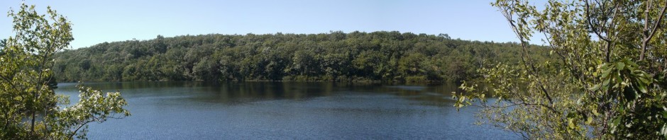
3:12 p.m.: A panorama of the final scenic view, on the other side of Round Hill:

View from Round Hill
The trail then began to descend sharply. I passed one man who was resting, apparently hiking alone. The descent continued to around 600′ or 500′, where I ran into a group of three hikers heading uphill. So even though these trails weren’t very busy, I did run into people from time-to-time. The trail finally descended to 400′ and then continued along a flat area for a while, eventually meeting the creek and running parallel to it, until finally rejoining the white trail at the site of the wrecked bridge. I measure that section of the blue trail at 3 miles. I took off my boots and socks and dipped my feet into the water, which was cold.
I then replaced my boots, crossed the bridge of two I-beams and continued walking back toward the lodge. At one point, I heard a loud rustling in the leaves and saw a deer, but unfortunately was not able to photograph her before she moved on.
4:25 p.m.: I then returned to the lodge and my car. I estimated that the total hike was 6.8 miles, though I read another hiker’s writeup that said it was 7.9 miles. Maybe one of us measured more accurately than the other. Anyway, it was a nice hike that took me 5 hours.