We flew into Calgary on Sunday night, August 12, and spent the night there. We had rented a Mazda 3 from Budget in Calgary, and it was a comfortable car. The next day, Monday, August 13, we did some grocery shopping and drove to Canmore, checking into the Rocky Mountain Ski Lodge.
Finally, on Tuesday, August 14, we drove to Banff National Park, only a few minutes north of Canmore. Neither of us had been hiking for the greater part of a year, and while I had been accumulating time and meters on our rowing machine, Batya suggested we start with an easy hike. I suggested the 5.7-mile Garden Path Trail, a relatively flat hike, which our Lonely Planet guide book said was accessible via shuttle bus from Sunshine Village. We drove to Sunshine Village, but then made two unpleasant discoveries that either were not mentioned in the guide book, or which I had overlooked. First, Sunshine Village is a ski resort that is private property grandfathered into Banff National Park. They sell lift tickets in the winter, and sell seats on a shuttle bus in the summer. Tickets seemed expensive, considering it was a 15-minute-ride to the top. Second, the buses only ran until around 5:00, and I had concerns that we would not be able to complete the hike in time to catch the return bus down the mountain.
My experience in U.S. National Parks is that the shuttle buses are usually free throughout the park, and don’t stop running at 5:00 p.m. during the middle of the summer. In Banff, sunset wasn’t until 9:04 p.m.! (We also learned that it was not only the private Sunshine Village shuttle that stopped service so early, but even the free shuttle buses operating elsewhere in the park.)
Happily, we had other options available, so we drove to Johnston Canyon, considered the most popular hike in Banff. The parking lot was full, but it was legal to park along the road leading to the parking lot, and we joined dozens of other cars there. The beginning part of the hike is considered easy, with little elevation change, running through Johnston Canyon and along the Johnston Creek.

Batya stands at the entrance to Johnston Canyon
We started hiking north, and the trail soon reached Johnston Creek, running to the right (east) of the trail. There were many tourists ascending and descending the trail.

Johnston Creek
This part of the trail was largely flat. Some of the trail was asphalt. In places, the trail was constructed of concrete panels that were cantilevered from the rock wall to the left of us. After 1.1 km (0.7 miles), we reached the Lower Falls.
Here, a bridge crossed the creek to an observation point where one could admire the Lower Falls. In addition, there was a short tunnel through which one could walk to a small viewing platform offering a closer look at the falls. The tunnel and viewing platform only had enough room for 2-4 people at a time, so there was a line of tourists waiting for their turn. We joined the queue and waited patiently. In this photo, you can see the falls at center, the bridge and waiting tourists at the bottom right, and the tunnel on the right side:

Lower Falls
Here is the close-up view of the falls from the viewing platform within the tunnel:

Lower Falls from Tunnel’s Viewing Platform
Leaving the Lower Falls, we crossed the bridge back to the west side of the creek, and continued hiking north. The trail was now packed earth. There was a bit more elevation change over the next 1.5 km (0.9 miles), but it still only totaled about 140 meters (400′) of gain. The crowd of tourists continued with us.

Johnston Creek
After an hour, we reached the Upper Falls, which have a drop of about 40 meters (130 feet). The first photo is from a viewing platform around the bottom of the falls:

Upper Falls
Another view of the Upper Falls, from a higher platform:

Upper Falls
A large percentage of the tourists turned back at this point, having reached the Upper Falls after 2.6 km (1.6 miles) of hiking. However, as Batya was doing well, we decided to continue on to the Ink Pots, even though the added distance and elevation would make this an easy/moderate hike instead of the easy hike she had originally requested.
We therefore continued on another 2.6 km, this time hiking through forest, and continually gaining about 200m (650′) of elevation. The trail was more rugged, though still very easy to follow:

Ink Pots Trail
This image, a fused High Dynamic Range composition, shows the Hillsdale Slide in the vicinity of Mt. Ishbel, which occurred in early post-glacial times:

Hillsdale Slide
This would be a good time to mention the forest fires. For the past few years, there have been forest fires in British Colombia during the summer months, and unfortunately this year was no exception. Banff is in Alberta, but borders British Colombia, and in fact the smoke created problems for a significant part of Canada. It seriously affected our visibility, and at times we could smell the smoke in the air.
Trees on the Ink Pots Trail:

Trees on the Ink Pots Trail
At 5.2 km (3.2 miles) into the hike, we reached the Ink Pots, five small mineral springs that vary in color.

Ink Pot
The Ink Pots themselves were underwhelming to me, especially after having seen similar pools (and some much larger ones) at Yellowstone.

Ink Pot
The scenery in general was nice, though as noted, the forest fires in the adjacent province cast a pall.

Ink Pot
I’m sure that the site would have been more impressive if the skies had been clear.

Ink Pot
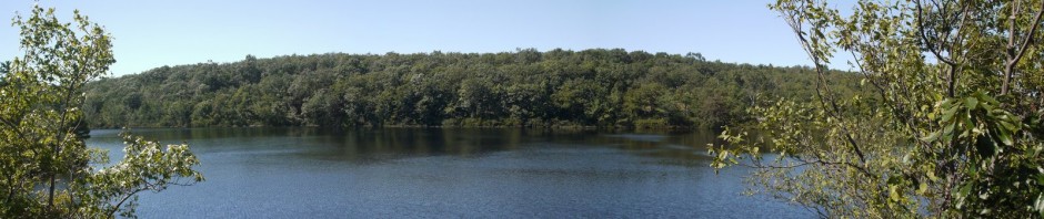
I’ll end with a stitched panorama that provides some idea of the surrounding mountains, and I imagine that many more would have been visible if not for the smoke:

Panorama of Ink Pots and Meadow
We then retraced our steps on the Ink Pots trail and the Johnston Canyon trail, completing the 10.4 km (6.5 miles) hike, which had an elevation gain of about 340 meters (1,100 feet). [Guide books and Internet sites give widely varying distances and elevations for the hikes in Banff, and I cannot guarantee that my numbers are accurate.]