Friday: We decided to tackle Mount Mansfield, which at 4,393′ is the highest point in Vermont. The mountain is only about a ten minute drive from Stowe.
10:56 a.m.: We parked at the Gondola Base Lodge, at around 1,500′ elevation.

Gondola lift
11:00 a.m.: We quickly found the trailhead for the Haselton Trail and began our ascent.

Haselton Trail
11:30 a.m.: It was a beautiful day for hiking.

Haselton Trail
11:32 a.m.: A series of zip-lines had just been put into service at Mt. Mansfield, and at this point in our hike the trail passed directly beneath the parallel twin wires of the zip-line. The lines ran to a very large nearby platform, where that zip-line ended and the next began. While I’m sure the zip-line is quite fun, it is somewhat disconcerting to be enjoying a hike in nature and then to suddenly hear the singing of a wire cable, accompanying by the excited screams of riders.
11:38 a.m.: We crossed a tiny stream of water, though the rocks suggested that at times there was more water passing there:

Rocky stream crossing
11:48 a.m.: A tree grew around a large rock:

Tree growing around a large rock

Haselton Trail
12:01 p.m.: The trail briefly broke into the clear, crossing an unmarked service road. However, we crossed the road and re-entered the woods.
12:35 p.m.: The trail again left the trees, climbing adjacent to a ski slope, now green.
12:41 p.m.: The ski slope in summer:

Ski slope in summer
12:54 p.m.:

Batya climbs the ski slope

Ski slope in summer
1:10 p.m.: We spent a half hour climbing the ski slope. It would probably only take a skier a minute or two to descend that distance in the winter:

Ski slope in summer
After 1.6 miles, we reached the auto toll road, at 3,100′. This is a 4.5-mile road for people who prefer to drive up to the mountain. It begins south of the gondola base, from a point a little lower on the mountain, at 1,302′ elevation. The toll seemed insanely expensive to Batya and myself, but perhaps we are overly frugal. The charge is $19 for a car (and its driver), with an additional $6 for each passenger.
We followed the auto toll road for 0.5 miles, climbing another 600′ to the road’s terminus at a parking lot at around 3,700′ elevation. At this point we had been hiking for over two hours and had only covered 2.1 miles, a very slow pace, though that included an elevation gain of about 2,200′. We sat on a large rock and ate a leisurely lunch.
Adjacent to the parking lot was a small visitor’s center, manned (or womanned) by volunteers from the Green Mountain Club. In addition to providing directions and information, the volunteers sought to educate visitors to avoid the alpine tundra at the high elevations of the mountain.
The ridgeline of Mt. Mansfield has a number of high spots, traversed by the Long Trail. When viewed from the east or west (and a few miles away), the mountain is said to resemble a human profile (facing the sky). These peaks are referred to as the forehead, nose, lips, chin, and Adam’s apple. However, in this particular “face” it is not the nose that is the highest point, but the chin. The visitor’s center is just north of the nose, and about 100-150′ below it. We did not climb to the nose, though, instead turning south and climbing toward the chin.
2:09 p.m.: We turned north toward the summit of the “chin,” 1.4 miles away and still about 700′ in elevation higher:

Long Trail sign
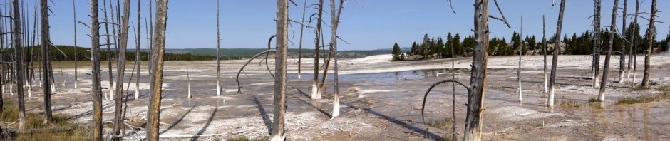
The Long Trail provided beautiful scenery on Mt. Mansfield:

Panorama
As discussed, we followed the Haselton Trail part of the way up the mountain, and then the Long Trail. The Long Trail itself can be followed all the way up the mountain, either from the south or the north, and there are also other trails that join the Long Trail, from both the east and west of the mountain ridge.
2:18 p.m.: I took a 360-degree panorama from a spot still fairly close to the “nose”:

360-degree panorama
2:42 p.m.: We continued hiking north on the Long Trail, growing closer to the “chin”:

Chin of Mount Mansfield
Batya scrambling toward the top:

Batya scrambling toward the summit
2:54 p.m.: Getting close to the top:

Chin of Mount Mansfield
. . . closer . . .

Chin of Mount Mansfield
3:15 p.m.: Made it to the top! After climbing about 2,900′ over the course of 2.7 miles, we reached the summit. Here’s another 360-degree panorama, this one from the “chin” of Mt. Mansfield, the highest point in Vermont:

360-degree panorama from the summit
Batya at the highest point of Vermont:

Batya at the summit
Charlie at the summit:

Charlie at the summit
Together (taken by a kind stranger with my cell phone):

Charlie and Batya at the highest point in Vermont
3:38 p.m.: We began our descent:

Descending from the Summit
I had originally planned to take the Long Path north from the summit, however the Green Mountain Club had another volunteer posted at the summit (to give directions, answer questions and particularly to ask people to avoid walking on the alpine tundra). She said that the section of the Long Path immediately north of the summit was exposed and not a good route for anyone who might be nervous about heights. She instead recommended that we backtrack a short distance north on the Long Trail and then turn onto the Profanity Trail. Batya asked the guide why the trail had been given such a name, and the guide thought that because it was a trail to be used in case of bad weather (being less exposed and thus less a lightning risk), the bad weather might invoke profanity. We developed our own theory, as the short trail was pretty much a non-stop scramble requiring very slow going.
3:58 p.m.: I somehow tripped over this tree root, falling . . .

Cruel tree root on the Profanity Trail
. . . and tearing a hole in one of my treasured hiking pants, with which I have been on so many adventures. For a while I couldn’t find any manufacturers of cotton/poly pants in my inseam (and without the zip-off lower leg convertible feature). Now they seem to be available once again from Lands End, though reviewers allege that they aren’t always true-to-size, so I am a bit afraid to order a pair. Luckily, the damage was mostly confined to the pants, though I also did have a superficial cut on my leg to match the minor cut that my finger had received while replacing a brake light in my car days earlier.

Torn hiking pants

Profanity Trail
4:32 p.m.: We finally reached the bottom of the hated Profanity Trail:

Bottom of the Profanity Trail
4:49 p.m.: At this point, we rejoined the Long Trail heading north, well clear of the exposed area that the guide had suggested we avoid. There were plenty of trees now, so it was no longer exposed, but it was still steep and required yet more scrambling. So while we were clear of the Profanity Trail, the scrambling continued unabated.

Scrambling down the Long Trail
6:44 p.m.: The Long Trail finally reached the road, about 0.6 miles north of the Gondola station. It only took us a few minutes from this point to return to the station’s parking lot, where we had left the car. The loop was probably only 7 miles or less, though the 2,900′ in elevation gain was impressive, with beautiful views.
The hike had taken longer than we had anticipated, with the extensive scrambling and with Batya still suffering some discomfort from an ill-fitting boot. Still, it was a great day and a great hike!
We made it back to the hotel about 45 minutes before the start of our Sabbath. We just relaxed at the hotel, though we were able to enjoy a parade of classic cars that drove by our hotel on Saturday afternoon. Stowe hosts a classic car show every year, and the parade route was very convenient for us.
Sunday: Shelburne Museum and Teddy Bears