Thursday: We drove south to hike at Killington Peak, which at 4,229′ elevation is the second highest mountain in Vermont.
Whereas Camel’s Hump–which we had attempted to hike earlier in the week–is undeveloped, Killington has a restaurant at the summit, with a gondola leading there. I would prefer to climb peaks that don’t have an easier way to the summit. Maybe that’s a bit of snobbery, as I think that the beautiful view should be restricted to those who choose to climb to the top as I am doing. Maybe I’m also influenced by a bit of laziness, thinking, “Why am I climbing this peak when I could instead drive or ride to the top?” In any event, I have enjoyed a number of hikes even though there were alternate ways to the peak, and we set out this day to climb Killington even though we knew that we would encounter non-hikers there.
Our hike primarily followed the Bucklin Trail, which began on Wheelerville Road, one of the dirt roads that I learned is fairly common in Vermont. Once again, my GPS took a circuitous route to the trailhead, but we got there.
11:44 a.m.: At the first the Bucklin Trail was perfectly level:

Bucklin Trail trailhead
12:02 p.m.: However, it soon began gaining in elevation:

Bucklin Trail
1:06 p.m.: A tree with a significant hollow provided a good prop:

Batya in front of hollow tree
The red elderberry, Sambucus racemosa, is poisonous when raw but supposedly edible when cooked. I think I’ll pass.

Red elderberry

Red elderberry
2:45 p.m.: The Bucklin Trail ended and we turned right (south) onto the Long Trail. After 0.2 miles, we reached the Cooper Lodge, erected by the Green Mountain Club.

Cooper Lodge
From the Cooper Lodge, the Long Trail continued south, but we instead turned east onto the Killington Spur Trail, which led 0.2 miles to the summit of Killington Peak:

Signpost
This 0.2 miles included some scrambling, though it wasn’t too taxing:

Killington Spur Trail
I remembered to look back and was rewarded with a nice view:

Scenery from the Killington Spur Trail
2:57 p.m.: Batya shows off her scrambling abilities:

Scrambling up the Killington Spur Trail

Scrambling up the Killington Spur Trail
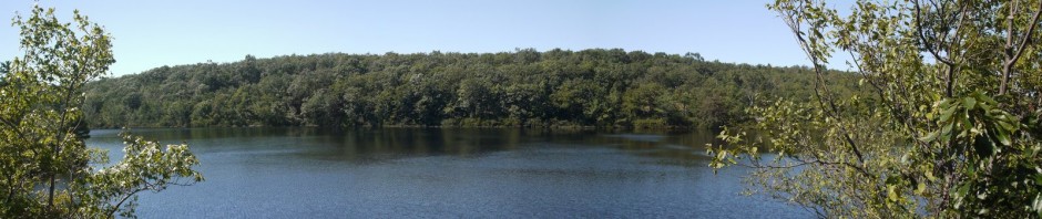
3:02 p.m.: We reached the summit, and it provided a pretty view!

Panorama from the summit
Another panorama from the summit:

Panorama from the summit
3:18 p.m.: Batya took a photo with my cell phone, which allowed me to upload a report of our adventure to Facebook:

Charlie at the summit
3:29 p.m.: A small trail led us off the bare rock and through a forested area, descending a bit:

Forested area between summit and gondola terminal
We soon reached the gondola terminal and a restaurant, which included restrooms with running water.
3:54 p.m.: From outside the restaurant, I photographed another series of photographs that I was later able to turn into this panorama:

Panorama from restaurant
4:11 p.m.: We returned to the summit and then began our descent on the spur trail, retracing our steps:

Descending the Killington Spur Trail
I did not see Killington Peak listed as one of the alpine tundra regions of Vermont, but the summit itself was bare rock, and just below the summit were trees that were quite short in stature:

Pine
A last view of the surrounding countryside, as we began our descent:

Scenery from Killington Spur Trail
The total hike was around 7 miles, with an elevation gain of 2,350′. For Killington Peak, it’s well worth skipping the gondola and instead hiking to the top on the Bucklin Trail.
Next: We climb Mount Mansfield, the highest point in Vermont!