This was a solo hike, and I decided to check out trails in Tranquility Ridge County Park, Long Pond Ironworks State Park, and the southwestern part of Sterling Forest.
11:30 a.m.: I parked at the Monksville Reservoir boat launch on Beech Road, and then walked north. The NY-NJ Trail Conference map #100 for Sterling Forest shows that a green-blazed trail parallels Beech Road, but the map does not show any access to the parking lot, and I did not see any access while I was there. Thus, I began my hike by walking 0.3 miles north on Beech Road, past the dead end, to where a gate barred any further vehicles. At this point I entered Tranquility Ridge County Park and was able to pick up the green trail, though it ended almost immediately at a point on the yellow-blazed Hasenclever Iron Trail.
From this point, one could take the yellow trail straight (northwest), or take a sharp right into the woods (northeast). I continued straight on the yellow trail, and within minutes came to Beech Brook, a tributary of the Wanaque River. [In 1987, the Wanaque River and Beech Brook were impounded to form Monksville Reservoir.] It might have been challenging to find stepping stones to cross Beech Brook, but luckily there was a very substantial bridge there.
This bridge actually struck me as being quite odd, because it is obviously not a pedestrian bridge, but rather a very substantial vehicular bridge of concrete, steel, and asphalt, complete with guard rails. In addition, the east side of this short bridge had about a 3′ vertical difference between the ground and the bridge deck. There had apparently been vehicle traffic here serving Beech Farms into the 1960s, and the bridge was a relic from those days. At one point there must have been an approach to the bridge on the eastern side that had compensated for the 3′ vertical difference, and even with vehicles no longer using the bridge, I was surprised that no one had arranged steps of wood or stone to assist hikers in climbing to or from the bridge. The bridge design itself provided for a step at about the halfway point, but a 1.5′ step is almost three times the height of an average 8″ step.

Bridge over Beech Brook
A view of Beech Brook, from the bridge:

Beech Brook
Almost immediately after crossing the bridge I came to an intersection of the yellow trail and a prominent old woods road. A sign explained that the woods road led to the former site of the Beech Farms, where people had lived until the 1960s. That woods road and others are shown on my map, but I continued west on the yellow trail. At this point I had only traveled about 0.3 miles from the gate at the end of Beech Road.

Intersection of Hasenclever Iron Trail and woods road to Beech Farms
The yellow trail left Tranquility Ridge County Park and entered Long Pond Ironworks State Park.
11:52 a.m.: After another 0.5 miles, the yellow trail skirted the Monksville Reservoir, which I could see peeking through the foliage:

Monksville Reservoir
This tree did not seem to have fallen, but it sure was leaning:

Leaning tree
Wild flowers:

Wild flowers
After another 0.5 miles, the yellow trail ended at an intersection with the teal-blazed Highlands Trail (which in this area was also blazed blue as the Sterling Ridge Trail). I also saw orange ribbons tied to trees at this intersection; orange ribbons may indicate the intent to blaze a new trail. I followed these ribbons about 50′ to the west, where they ended at the Wanaque River. I am not sure what the orange ribbons were trying to point out, though I noticed that they were passing over small quantities of coal and slag glass left from the iron works projects.
12:31 p.m.: I returned to the Highlands Trail and first followed it south for about 100 yards, arriving at the Wanaque River at what had once been a bridge crossing:

Wanaque River
I had known prior to my hike that this bridge was missing. It had been destroyed by Hurricane Irene in August 2011, and is slated for replacement in Fall 2013. The Wanaque River is no little stream or brook that can be crossed by stepping stones: that is deep water!
I noticed that on the west side of the Wanaque River there are a number of old structures associated with the Long Pond Ironworks. It might be interesting to visit someday, but with the bridge out, there was “no way to get there from here.”
I turned around and followed the Highlands Trail to the north. I previously complained about the trails in Sterling Forest, noting that many of them ran over old woods roads, which I found to be rocky and otherwise subject to erosion and flooding. I had been complimentary to the Highlands Trail, which was a footpath. However, I learned on this day’s hike that the Highlands Trail is also routed over old woods roads in some areas, and it seemed that a significant portion of the hike involved stumbling over rocks and either slogging through an ancient muddy road or detouring around mud puddles. At least these were historic woods roads, with some of them dating back to the mid-1700s.
The Highlands Trail intersected another woods road, and I stayed on the Highlands Trail. Here, the path crosses a tiny stream:

Highlands Trail at stream crossing
The map showed that I was leaving Long Pond Ironworks State Park and re-entering Tranquility Ridge County Park. I encountered many fallen trees that had yet to be cleared from the trails. In some cases I went around them; in other cases I climbed up and over them, as here:

Climbing over fallen tree
More fallen trees:

Fallen trees
The hike had started at around 500′ in elevation and had remained relatively flat on the way to the Wanaque River, at most gaining 100′. Now, however, there was a bit of a workout, as the trail climbed Big Beech Mountain, which peaks out at 1199′.
1:57 p.m.: Here the trail climbed past boulders:

Boulders on the Highlands Trail
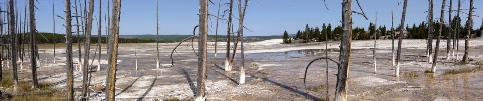
2:04 p.m.: I reached the one and only scenic view of the day, from Big Beech Mountain, looking toward the southeast:

Scenic view from Big Beech Mountain
2:30 p.m.: The trail crossed the border into New York, entering Sterling Forest:

Highlands Trail, at New York/New Jersey border
2:37 p.m.: About 2.2 miles from the Wanaque River, I reached an intersection with the east-west Lake-to-Lake trail, which is blazed white (with a red stripe). I turned west onto that trail, which was an old woods road, quite eroded and full of puddles.
2:42 p.m.: One of the visitors to the website said that I should recognize these puddles as vernal pools, important for many critters, such as these cute tadpoles:

Tadpoles
Is this Eastern American Toad, Bufo a. americanus, one of the parents?

Eastern American Toad
2:52 p.m.: Another puddle, er, vernal pool, and I met this wood frog, Rana sylvaticus. He blended very well with the leaves, and perhaps thought that I didn’t see him.

Wood Frog
This is an example of the erosion on the woods road used for the Lake-to-Lake Trail.

Eroded Lake-to-Lake Trail
2:59 p.m.: The Lake-to-Lake Trail dipped below the border into New Jersey for a short distance, cutting through both Tranquility Ridge County Park and Long Pond Ironworks State Park, before turning north into New York again.

Lake-to-Lake Trail at the New York/New Jersey border
3:06 p.m.: This is Jennings Creek, one of the tributaries of the Wanaque River. The trail had a bridge across the creek.

Jennings Creek
3:15 p.m.: After 1.1 miles on the Lake-to-Lake Trail, I came to a woods road that the map showed I wanted. I turned south and followed that for 0.2 miles, back into New Jersey. That brought me to the northern end of the yellow-blazed Jennings Hollow trail. [The northern end of the trail is an elliptical loop; I followed the eastern side of the ellipse to the south, and then at the southern end of the ellipse continued on a linear part of the trail.]
3:22 p.m.: I’ve seen plenty of twinned trees before, but I don’t know if I’ve ever seen triplets before. This was pretty cool.

Triplet trees
I had to again cross Jennings Creek, but this time without a bridge. This looks like fun!

Crossing Jennings Creek
But first, I took a photo of beautiful fungus growing at the base of a shattered tree:

Colorful fungus
Okay, I survived Jennings Creek without any trouble. While I was able to walk across the stepping stones without falling into the creek, it was very nice to be able to hold onto the ropes while making the crossing. Thanks to whoever left those ropes there for hikers!
4:02 p.m.: By now I was on the linear part at the southern end of the Jennings Hollow Trail. Here’s an oak tree with a huge burl in the middle of the trunk:

Burl in oak tree trunk
4:05 p.m.: Downed trees. I was probably due west of where all the downed trees had been on the Highlands Trail.

Downed trees
4:14 p.m.: After 1.5 miles, the Jennings Hollow Trail reached its southern end, intersecting with the Highlands Trail, which I followed to the south.
4:25 p.m.: The Highlands Trail passed under this arch of a fallen tree:

Highlands Trail passes under a fallen tree
4:28 p.m.: After 0.6 miles, the Highlands Trail reached the intersection with the yellow-blazed Hasenclever Iron Trail, and I turned onto that, heading the 1.6 miles back toward my car.
4:56 p.m.: Here the trail passes under vines:

Vines
I returned to my car around 5:15 p.m. I estimate the hike at 9 miles, and it took me 5-3/4 hours. As I noted, there wasn’t much elevation gain: one climb from 500′ to around 1100′ or 1200′, and otherwise it was flat or downhill.