New York City does not presently have any snow on the ground, but I thought that the parks that I frequent, being further to the north, might have snow. But how would I learn that? While weather reports can tell you what is happening at a place at the present time, there’s no easy way to find out if it has previously snowed there, with snow remaining on the ground. While cameras have proliferated in cities, most are recording for security, rather than presenting a feed that is publicly accessible on the Internet. Thus, the only webcams I was able to find that were helpful were from the parking lots of a couple of schools in Connecticut, showing snow on the ground. This suggested I would also find snow on the ground in the New York parks that I frequent. Therefore, I decided to choose a hike that was relatively flat, as I knew that I would not have good traction in snow.
I drove to Harriman State Park and at noon pulled into the Silvermine Picnic Area on Seven Lakes Drive. I began hiking west on the yellow-blazed Menomine Trail, which for 0.2 miles ran parallel to and just south of Seven Lakes Drive.
The trail then turned north, crossing the drive and re-entering the woods on the other side, where it ran along a woods road.

Menomine Trail, Harriman State Park, NY
12:14 p.m.: After another 0.2 miles, the path passed beside the northeastern edge of Lake Nawahunta:

Lake Nawahunta, Harriman State Park, NY
I kept going straight onto unblazed Nawahunta Fire Road. Many footsteps through the snow led the way on this woods road. The snow coverage was extensive, but there were a few areas that had somehow been spared:

View from Nawahunta Fire Road, Harriman State Park, NY
12:29 p.m.: The weather was definitely above freezing, and possibly hit the 40s. There were a fair number of streams and puddles that were not frozen.

Nawahunta Fire Road, Harriman State Park, NY
12:35 p.m.: The sky was a pretty blue color:

View from Nawahunta Fire Road, Harriman State Park, NY
12:57 p.m.: After 1.2 miles, the fire road ended at the Long Path, onto which I turned left (southwest). I was soon passed by an Asian man who was moving at a faster pace. In places the snow was slippery, and as I did not have poles or traction devices on my boots, I was content to move slowly and carefully.

Intersection of Nawahunta Fire Road and Long Path, Harriman State Park, NY
1:30 p.m.: I didn’t see any animals, but there were tracks everywhere.

Long Path, Harriman State Park, NY
1:36 p.m.: I spotted graffiti in the snow, which I suspect was left by the Asian man who passed me. Perhaps someone can leave a comment telling me what it says. Later on the path I saw a couple of smiling faces that had been drawn in the snow.

Snow Graffiti, Harriman State Park, NY
1:38 p.m.: Fallen trees across the Long Path:

Long Path, Harriman State Park, NY
1:50 p.m.: After about 1.2 miles on the Long Path, I reached the cave shelter on Stockbridge Mountain, and discovered that the Asian man had stopped there for lunch. I also ate my lunch there, and then asked him to take my photo.

Stockbridge Mountain Cave Shelter, Harriman State Park, NY
2:18 p.m.: Leaving the cave shelter, I followed footprints in the snow in the direction the trail had been moving, but I didn’t see any blazes. The footprints ended, suggesting that the people who had left them had also realized that they were off the path. I backtracked to the cave and finally discovered that the trail climbed up the hill immediately to the right of it. It was a bit steep and slippery, so I took my time climbing it. This is the view from the top looking down:

Long Path, Harriman State Park, NY
2:27 p.m.: There was a scenic view at 1200′ elevation:

Scenic View from Stockbridge Mountain, Harriman State Park, NY
2:30 p.m.: A fallen tree:

Fallen Tree on Long Path, Harriman State Park, NY
2:32 p.m.: Carefully climbing another hill, I reached the rear of the Stockbridge shelter.

Stockbridge Shelter, Harriman State Park, NY
I circled it carefully, as there was more slippery snow there, and saw a number of people. Four hikers had been talking to the people inside the shelter, who were having a barbecue.

Stockbridge Shelter, Harriman State Park, NY
The other hikers were going in the same direction as me, but they were better equipped, as they had poles and at least some of them had traction devices on their boots. So whereas I crept down the hill beside the shelter, they moved at a much faster pace and were soon out of my sight line.

Long Path, Harriman State Park, NY
2:45 p.m.: A rock wall with icicles:

Rock Wall on Stockbridge Mountain, Harriman State Park, NY
2:52 p.m.: About 0.4 miles from the cave shelter, I reached the Long Path’s intersection with the yellow-blazed Menomine Trail, on which I had begun my hike. I turned east, heading back toward my car.

Intersection of Long Path and Menomine Trail, Harriman State Park, NY
3:18 p.m.: Fallen trees:

Fallen Trees on Menomine Trail, Harriman State Park, NY
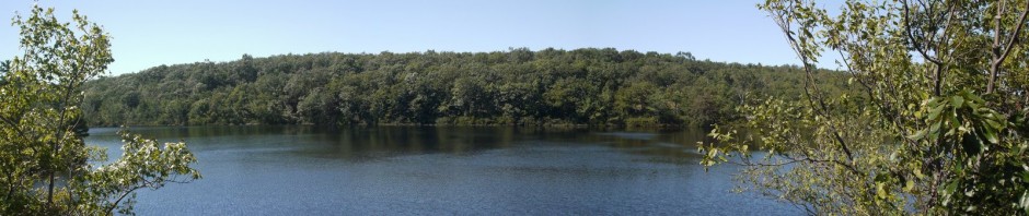
3:21 p.m.: Another view of partially-frozen Lake Nawahunta:

Lake Nawahunta, Harriman State Park, NY
3:45 p.m.: After about 1.4 miles on the Mekomine Trail, I returned to the Silvermine picnic area, and for a few minutes watched people sledding down the hill:

Sledding at Silvermine Picnic Area, Harriman State Park, NY
I estimate this was a 4.6-mile hike.