This Jewish Outdoors Club hike in the Catskills was limited to 15 people, but 7 canceled, leaving 8 of us. I gave a lift to Jonathan from my neighborhood, and we detoured into Brooklyn to pick up two ladies.
Our designated parking area was on Peekamoose Road, along Rondout Creek in the Sundown Wild Forest. As we turned onto the road we soon passed a few parking areas. In the first, I spotted two people standing by a car, at least one of whom looked familiar. Our GPS showed we still had 1.4 miles to go, but I suspected that they did not have GPS and had stopped too soon. Since we were so close to our destination, and running five minutes late, we decided to keep going rather than stop to see if they were with our party. We arrived at the parking lot at 10:35 a.m. and learned that we were indeed missing two people. There was no cell phone reception, so it was fortuitous that I had spotted them. I drove back the 1.4 miles, confirmed the people were the balance of our group, and asked them to follow me to the correct parking area.
Around 11:00 a.m., we started our climb northeast up the blue trail, being part of the Long Path. It was the only trail we would be on today, and we were “just” following it about 4.8 miles, then turning around and coming back. However, our destination, the peak of Table Mountain, was at 3847′ in elevation, while the parking lot was only at 1300′ elevation. So we had a climb of over 2500′.
11:06 a.m.: The hike began with a very steep incline for about 0.2 miles, at which point we arrived at a kiosk asking people to sign in so that the rangers would have an idea how many people were out there. We rested there for a few minutes.

The trail began with a steep incline
The hike description indicated that the first 0.8 miles of the trail followed an old woods road. In places there was tell-tale erosion of a road, though in other places it might have been hard to identify the trail as an old road.
11:52 a.m.: We left the Sundown Wild Forest and continued into the Slide Mountain Wilderness, with the blue trail turning into a footpath.

The trail becomes a footpath
11:56 a.m.: A break in the trees shows that we have gained some elevation. Our leader was moving at a fast pace, which would have been fine with me on level ground, but had me breathing hard as we were ascending sharply the entire time. We took a rest break around this time, as I was not the only one breathing hard.

Our first scenic view, as we gain some elevation!
12:03 p.m.: The hike included some scrambling:

Scrambling

More scrambling
12:34 p.m.: At 2.3 miles from the parking area, and at 2900′ elevation, we arrived at Reconnoiter Rock, a large boulder perched at the edge of a rock ledge. We took yet another break. I had slipped to the back of the pack, just in front of the sweep, and offered to the leader to take over as sweep or fall behind, as I didn’t want to slow down the group. But after this point (having climbed 1600′ in 90 minutes), the trail seemed to level out a bit, and we only had another 900′ to the peaks. Therefore, I was able to hike toward the front of the line after Reconnoiter Rock.

Reconnoiter Rock
12:52 p.m.: A tree grows among the rocks.

Tree roots grow around rocks in a search for nutrients
1:17 p.m.: At 3.05 miles into the hike, at 3500′ elevation, we reached an overlook offering fine views to the south. We took another break here, this time to enjoy the view, rather than to recuperate from the physical effort:

Scenic view from 3500′
I pose in front of Nature’s canvas:

Posing at 3500′
2:05 p.m.: At 3.9 miles into the hike, we reached the summit of Peekamoose Mountain at 3843′ elevation, where a snowshoe hare kept guard:

Snowshoe hare
The map does not show a scenic view from the summit of Peekamoose Mountain, but it appeared that a path had been recently cleared to establish a view:

View from the summit of Peekamoose Mountain
We continued on, as the path turned due north and then west. After another 0.85 miles, we were 4.75 miles into the hike, having reached the summit of Table Mountain, at 3847′. While only 4′ higher than the top of Peekamoose Mountain, there had been about a 150′ to 200′ descent into a col, and then a climb out of it.
2:39 p.m.: The summit of Table Mountain was not a noticeable prominence and was only marked by a rock cairn. However, we continued on about 0.15 miles and came to a small rock ledge offering a scenic view toward the southwest:

The view from Table Mountain
While the ledge was small, most of us squeezed onto it for a late lunch:

Lunchtime on a narrow ledge
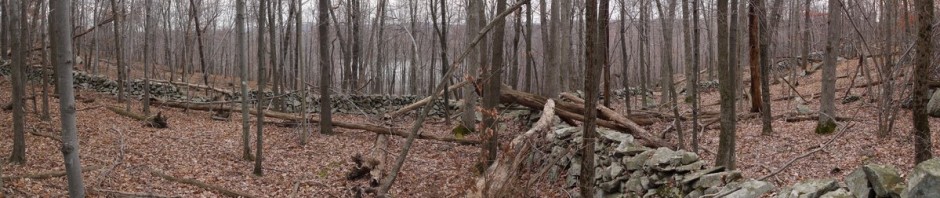
A wider panorama before leaving:

Panorama from lunch spot
And an HDR shot, made by combining overexposed and underexposed photos:

HDR panorama from our lunch spot
4:59 p.m.: We pass Reconnoiter Rock again, this time heading downhill. We had debates about the merits of going downhill versus uphill, as they worked different muscle groups. Some experience knee pain hiking downhill. On steep declines I occasionally develop “hot spots” on my big toes and the balls of my feet, and I worry those hot spots will become blisters. I was wearing a brand new pair of boots, but they were neither better nor worse than my old boots in this regard.

Reconnoiter Rock, on our descent
5:14 p.m.: We were following the path back the way we came. Here, one tree had apparently fallen and knocked down a second tree. Trail maintenance had cut a notch in the lower tree, to form a step. However, I think that if I had tried to stand on that step I would have hit my head on the upper tree. Thus, I stepped over the lower tree while ducking.

Fallen trees

Using the step that a trail maintenance crew notched into the tree
5:23 p.m.: This photo shows one of the steep declines:

Some hikers find a steep decline more challenging than a steep ascent
6:17 p.m.: We completed the 9.6 mile hike and returned to the parking lot, having bagged two of the 35 Catskill High Peaks. After tossing our backpacks in the cars, we crossed Peekamoose Road to check out Rondout Creek. The water was cold, but it felt good to dip my feet into it.

Rondout Creek
Getting home was a different story. We stopped for dinner at Woodbourne Pizza, which was fine. But whereas the drive from Brooklyn (where we had picked up the girls) to the Catskills was 2-1/2 hours, it took us 3-1/2 hours of driving to deliver them home, owing to traffic in the New York City area. Not knowing better, I took the George Washington Bridge to the FDR, and then followed that to the Brooklyn Bridge. I remained in the right lane for the Brooklyn Bridge, as the signs directed, which formed a long line 0.5 miles before the bridge entrance, as hundreds of cars flew past to then cross the solid line into the bridge entrance at the last minute. Cops did nothing, ignoring this violation of traffic law, which is apparently the practice of a great majority of New York drivers. I consider it to be rude and stealing time from others, and will not do it. We dropped off the ladies at the home of one of them, at around 11:00 p.m., and Jonathan and I didn’t make it back to Queens until 11:30 p.m.