“[W]hether we will or no, Majesty is all around us here in Berkshire, sitting as in a grand Congress of Vienna of majestical hill-tops, and eternally challenging our homage.” – Herman Melville, from the dedication of Pierre
Leaving home at 6:00 a.m., my objective was Mt. Greylock, the highest point in Massachusetts, located in the northwest corner of the state. I drove north across the Whitestone Bridge, then took the Hutchinson River Parkway, then I-684 (which cuts across a tiny corner of Connecticut before reentering New York). I then continued on Route 22, which took me through a number of small communities. One was Dover, New York, where I noticed a number of vacant buildings east of the highway. Research shows this was the Harlem Valley Psychiatric Center.
At one place on my drive, I noticed a big rabbit by the side of the road, and just as I was admiring it, a male cardinal flashed by in front of my car’s window. So for a fraction of a second, I saw two animals that I rarely see. It’s too bad that I couldn’t have a picture of that, but there are many moments that are simply too ephemeral to be captured by a camera.
8:00 a.m.: I only stopped once on my drive, still along Route 22, to admire a green field and the mountains beyond, which beckoned to me:

Farmland beside Route 22
I finally left Route 22 and headed east, crossing into Massachusetts. I arrived at the Mount Greylock State Reservation around 9:15 a.m. The trail begins at the end of Hopper Road in Williamstown:

Hopper Road trailhead
While a gate bars vehicular traffic, it seems that Hopper Road continues for a fraction of a mile as a former 1830s carriage road. Fields have been cleared to the north and south of the road, but somehow a narrow border of trees remain on each side of the road to provide shade and separation from the fields:

Hopper Road Trail
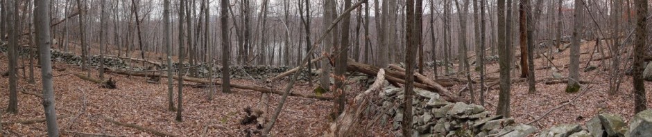
Here are fallen logs covered in moss, along the southern border of the trail. Just beyond, you can see the cleared field to the south of the trail.

Hopper Road Trail
I want the Money Brook Trail, to the left. To the right is the Haley Farm Trail, which will be my return path, as my route will take me in a giant clockwise loop.

Intersection of Hopper Road Trail and Haley Farm Trail
Looking to the right, a path of trampled grass marks the Haley Farm Trail. I make a note of it for the end of the day.

Haley Farm Trailhead
Another crossroads. Again, I want the Money Brook Trail, to the left. The Hopper Trail takes the right fork.

Intersection of Money Brook Trail and Hopper Trail
This is a detail of nearby trees, and you can see that the trees in the background are quite concealed by fog. The chance of rain had been projected as 40%, and I decided to take a chance. I did not encounter rain, but it had rained a lot, and conditions were muddy at times. Also, the fog never burned off, and sadly I was not able to enjoy any views from the mountaintop or outlooks.

Foggy day at Money Brook Trail
9:35 a.m.: There is a reason they call this the Money Brook Trail: there’s actually a brook here. The trail roughly parallels the brook for a few miles. At first it runs southeast, then makes a 90 degree angle and runs to the northeast.

Money Brook
9:43 a.m.: The Money Brook Trail begins an ascent:

Ascending on the Money Brook Trail
10:01 a.m.: Perched on a nice wooden bridge that straddles the brook, I put my camera down and take a longer exposure:

Money Brook
11:07 a.m.: The Money Brook Trail continued higher, and I finally was able to take a short detour to the base of Money Brook Falls:

Money Brook Falls
11:42 a.m.: The Money Brook Trail continued on a roughly northeast direction, reaching a primitive campground called Wilbur’s Clearing. No one was camping when I arrived. Here is a shelter for those who want to enjoy a meal out of the rain.

Shelter at Wilbur’s Clearing
11:50 a.m.: The trail continues on puncheon through some especially wet areas:

Puncheon

Puncheon
11:54 a.m.: After 3.75 miles, the Money Brook Trail finally reached an end, intersecting the famed Appalachian Trail. I don’t remember if I’ve ever hiked any part of the AT before. Hopefully I’ll remember that I did so on this occasion. I decided to take a 0.3 mile detour to the northwest, to a lookout.

Intersection of Money Brook Trail & Appalachian Trail
12:05 p.m.: Arriving at the lookout, I feel pretty stupid, as I realize that it’s so foggy that there’s nothing to see. If it had been a clear day, I would have had a vista of Williamstown.

Foggy vista

Flower
I reversed course, following the AT south. (It actually ran east for a while, before turning due south.)

Appalachian Trail
1:12 p.m.: I reach the peak of Mt. Williams, at 2,951 feet.

Peak of Mt. Williams
2:31 p.m.: As I have said, it was muddy in places. I met a few hikers, though they were always close to where the trails intersected roads. Thus, I don’t know if any of the ones I saw were walking a long distance on trails, or if they had just entered from the road and were walking along the trails for a short distance.

Muddy trail
Of course, slugs thrive in wet conditions:

Slug

Flowers
3:10 p.m.: After 3.75 miles on the AT (plus another 0.6 miles to that “vista of Williamstown”), I finally arrived at the peak of Mt. Greylock, at 3,491 feet elevation. The mountain has been an inspiration to many poets and writers, and some of their thoughts were engraved in rocks at the summit. Herman Melville had a view of Mt. Greylock from his farm, Arrowhead, and he said that Mt. Greylock appeared to him as a breaching whale, inspiring him to pen Moby Dick.

Stone engraved with quotation from John Ruskin

Stone engraved with quotation from John Bascom
This shot of the 93-foot high Massachusetts Veterans War Memorial Tower shows how foggy it was.

Massachusetts Veterans War Memorial Tower

Directional signs
I met a couple who had biked to the summit (on the roads, not on trails). The man commented that at least there weren’t any crowds this day. I have no idea how many people there would be on a sunny day, but the mountaintop was practically deserted.

Foggy observation point

U.S. Coast & Geodetic Survey magnetic station

Stone engraved with quotation from Henry David Thoreau

Elevation sign
The Veterans Memorial was open, and I went inside. I was shocked to see the poor condition, with water leaking inside, letters having fallen off the inscriptions, etc.

Interior, Massachusetts Veterans War Memorial Tower

Interior, Massachusetts Veterans War Memorial Tower

Interior, Massachusetts Veterans War Memorial Tower

Interior, Massachusetts Veterans War Memorial Tower
I climbed to the top of the tower, just for the exercise and to say that I’d done it. I knew by now that there would be no view other than impenetrable fog.

Whiteout
Back outside:

Appalachian Trail marker, Mt. Greylock, MA
This was pretty cool: a relief map of the mountain and surrounding area, drawn at a scale of 1 foot = 1 mile.

Relief map, Mt. Greylock, MA

Stone engraved with quotation from Henry David Thoreau
I left the summit and resumed walking southwest on the AT for another 0.6 miles. Then I took the Hopper Trail (a different part of it than I had seen at the beginning of my hike).
4:51 p.m.: After 1.2 miles of the Hopper Trail, I came to Sperry Road. This is a nicely graded road, though a gate “discourages” vehicular traffic. I followed this road 1.4 miles northwest, and it was pretty easy walking, though I was getting tired at this point. There are a number of primitive campsites along this road.

Sperry Road
A nice little stream visible from the road:

Stream off Sperry Road
5:18 p.m.: At the end of Sperry Road, I reached the Stony Ledge Vista. Of course, there was nothing to see.

Foggy day at Stony Ledge Vista
There were some pretty flowers there, though.

Wildflowers at Stony Ledge Vista
I followed the Stony Ledge Trail for 0.1 miles, then veered off onto the Haley Farm Trail, which I had noted at the beginning of my hike. Interestingly, the Haley Farm Trail does not appear on the USGS Survey Maps. I wonder if it’s a newer trail. It started out heading north, then west, then north again, meandering 2.2 miles.
5:30 p.m.: Very colorful lichen:

Lichen
5:48 p.m.: I know this is a crummy photo, but it’s an American Porcupine. They are apparently nearsighted, and I wonder if this one wasn’t also hard of hearing. I wasn’t getting good shots of him and tried a flash, and that got his attention and he slowly waddled off, even though I tried reassuring him that I wouldn’t hurt him. While there was still more than two hours of daylight, it was getting pretty dark. I guess the overcast skies and the foliage overhead blocked out most of the sunshine. I knew that I must have been getting close to the end of the trail (and I also had a flashlight with me), so I wasn’t too worried.
")
Blurry photo of American Porcupine
6:17 p.m.: The Haley Farm Trail runs out of forest.

Haley Farm Trail

Haley Farm Trail
As I crossed the field that I had photographed at 9:15 a.m., I took one last shot of the foggy horizon.

Haley Farm
This 13.6-mile hike took me 9 hours. I then had a long drive home, arriving around 10:00 p.m.