Nachi suggested a short hike in High Tor State Park, and ten of us participated. It was not the prettiest of days, with gray skies and temperatures in the 40s, and obviously no green vegetation.
Rather than starting the hike in the park, we met at a parking area about 1/2 mile outside the park, off Old Route 90 (Haverstraw Road), east of County Road 23. Our route was on maps 111 and 112 of the New York-New Jersey Trail Conference “Hudson Palisades Trails” series. The parking area is not marked on map 111, but is at GPS coordinates 41.1771, 73.9604.
Nachi called the meeting for 10 a.m., but some drivers were late, got lost, etc., and as a result we didn’t begin hiking until around 10:40. We began walking a short distance west along Haverstraw Road, following the aqua blazes of the Long Path, which turned north into the woods shortly after the intersection with Country Road 23.
10:47 a.m.: The Long Path soon passed an old stone wall and began a gradual climbing. The road was at 200 feet in elevation, and the high point reached during the day would be 830 feet, at High Tor.

Stone wall
By 10:57, we had already entered into High Tor State Park, on map 112, and we passed the white-blazed Spur Path. We continued on the Long Path.
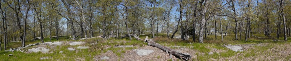
11:03 a.m.: Around 500′ of elevation, the path turned northwest, skirting around a hill.

High Tor State Park
11:09 a.m.: While there was no greenery, the hikers provided more than a touch of color.

Hikers in High Tor State Park
11:13 a.m.: The Hudson appears in the background:

Hikers in High Tor State Park
11:14 a.m.: The group gathered for a moment just below the peak of High Tor.

Below High Tor
We then climbed the remaining 20′ for an unobstructed 360 degree view, but it revealed an ugly quarry below, and I think the obstructed view presented above is nicer.
We resumed our hike to the northwest, at a leisurely pace, stopping when we reached Little Tor, at about 710′ elevation, where we stopped for lunch.
12:11 p.m.: The scenic view here was a little nicer. Instead of the ugly quarry, we had a nice view of the western part of Haverstraw, as well as the Hudson.

West Haverstraw
The area has a lot of history. High Tor was used as a signal point by colonists during the Revolution. Benedict Arnold met an English general at a beach in Haverstraw and offered to sell plans to West Point. And in the late 1800s, Haverstraw was the leading center of brick production in the United States. The property was at risk of being quarried for its trap rock, but locals rallied to save it, and it was purchased and made a park in 1943.
In Haverstraw, a water tower in the town is owned by–or advertises–the local hospital, which is named for the famous actress and philanthropist, Helen Hayes.

Water tower in Haverstraw
After lunch, we explored another little side path which took us around the west of Little Tor. The view here was of a different character, as we were now looking toward the western part of High Tor State Park (and perhaps also toward South Mountain County Park), and thus away from the residential areas of the surrounding towns.

Scenic view from Little Tor, High Tor State Park
We began hiking back. There was no loop path here, or at least not to our knowledge, and thus we retraced our steps on the Long Path.
1:35 p.m.: I pose for a photo with Yitz, one of my apartment mates.

Yitz and Charlie
1:50 p.m.: On the return path, I spotted a place where the Long Path has been rerouted, taking a short cut. While the other hikers retraced their steps on the path that we had followed earlier, I decided to follow the partially-obscured blazes that marked the old route of the trail.

Old Route of Long Path at High Tor
1:51 p.m.: The old route paralleled the new route, but at a higher elevation to the north. I could see my fellow hikers moving below me:

Old Route of Long Path
1:53 p.m.: The old route ended at the top of a steep hill, which I had to descend with a hand and foot scramble, rejoining the others below. The photo doesn’t reflect how steep the scramble was. It was safe enough in the dry conditions of that day, but perhaps the path had been rerouted with wet or snowy conditions in mind.

Old route of Long Path, including scramble
After only a few minutes on the old route and scramble, I soon rejoined the rest of the hiking group.
2:12 p.m.: When we reached the white-blazed Spur Path, we detoured on it to the west, visiting a small pond for a few minutes.

Pond off Spur Path
We then returned to the cars, having completed a roughly 5.5 mile hike. It was not very strenuous, as we were moving at a slow pace and did not have a great deal of elevation gain.
While not a pretty day, I am always happy to get out and exercise, and the company was nice. This was also the first time I visited High Tor State Park, and I am glad to add it to my list.
thank you for chronicling your day as it brings back great memories of my childhood. My childhood friends and i grew up in the four seasons development in the 60’s. In the summer we would camp out on the twin peaks of the low tor mountain. We were 10,11 & 12 years old at the time- would that even be considered now. we knew that patch of mountain from high to to low tor like the back of hands. we would catch salamanders in salamander pond and watch the turtles sun on the logs. On very hot days we would hike down to the hi tor pool to swim- great memories looking for treasure and telling stories about the Indian chair and that huge stone that is/was hanging on the cliff over where eventually condos were built- thxs for the flashback
Thank you for your comment. It must have been nice growing up near such a park. Perhaps younger kids in some states can still camp on their own, but it is less common today.
As Donald I myself grew up on the mountain side just west of low tor facing northeast with a view from Low Tor mountain to Jones Point on the Hudson across from Fishkill. I was in the development just before south central hwy. The whole top of the mountain was our playground for my friends and neighbor’s. We had access from the top of Tulip Tree Dr. Or if we wanted to we could have went in from many places along South Central Hwy to the top of the mountain above the lookout parking area at the west end of the fire trail. But none the less we always took the short cut from the top of South Central Hwy and Tulip Tree Dr. We had a friend who lived back in the woods on state land which the dirt road leading to his house was on the way up to the fire trail just east of the entrance from South Mountain Rd. We used to run dirt bikes, dune buggy, gocarts and bicycles or just plain hike and camp out at times. Now it gave us the freedom to hike all the way to Low Tor and high for as well as going up to the Indian Chair and all the way out to Haverstraw at the cut of the mountain off of 9W. It was our access to the high Vention towers which comb the mountain or as Donald said to hi for state pool, also goldfish pond which is behind Low Tor mountain in a valley instead of turning north you would go south down the hill. Now here’s another trail but stops short in a new housing development which Low Tor ice skating rink use to be many moons ago but you can still get off the trail between the houses. Now if you’re really adventurous the fire trail west of the fire trail on the east side of South Central Hwy you can take that all the way out to route 45 in Mount ivy in Pomona just south of route 202 half way up the hill on the left hand side across from the parkway entrance north bound. So there you have it an all day hike or break it down in two days, just be careful of the wild life we still have black bears roaming around. Albert.