I had planned on hiking with the Appalachian Mountain Club, but arrived at the meeting place a few minutes late and they were gone. I continued on my own to Wawayanda, which I understand is pronounced “way way yonder,” a cutesy name with spelling that is falsely suggestive of a Native American origin.
I drove into the park entrance of Warwick Turnpike and parked at the office.
9:55 a.m.: I began hiking north on the blue-blazed Hoeferlin trail, which was thoroughly covered with leaves.

Hoeferlin trail
After 0.2 miles I came to the intersection with the Appalachian Trail, but the NY-NJ Trail Conference map showed a number of mines on the blue trail north of this intersection, so I decided to continue on the blue trail to see if anything was visible. I continued on another 0.75 miles, until the blue trail intersected a dirt road, which was past what the map showed as the “Green Mine” and two unnamed mines. At this point, I was less than a mile from the border with New York State. However, I didn’t seen anything that looked like a mine, and I backtracked south 0.75 miles on the blue trail.
10:25 a.m.: I turned west (southbound) on the Appalachian Trail.

Appalachian Trail
I practiced spotting crushed leaves or depressions in the trail that would indicate the path, and only looking for blazes after deciding which way the trail went.

Crushed leaves mark the trail
The route I took this day was very flat, for the most part, ranging between 1100′ and 1300′ of elevation. Here, a few rocks help hikers descend a very short hill.

Stepping stones lead downhill
The AT crosses an old woods road.

Old woods road
10:49 a.m.: After 0.75 miles, I passed north of Kazmar Pond.

Kazmar Pond
Puncheon leads across a muddy area near the pond. They could have used a few more pieces of it.

Puncheon
A stream led from Kazmar Pond:

Stream
10:58 a.m.: After another 0.3 miles, the AT briefly joined the blue-blazed Iron Mountain Trail, which runs entirely on a woods road. The stream from Kazmar Pond fed into Wawayanda Creek, substantial enough that a bridge was needed to cross it. The AT thus made use of the obsolete bridge on the Iron Mountain Trail, which dates from the 1890s. I’m not entirely satisfied with this shot, as the berries aren’t as focused as I would prefer, but in the background one may see the bridge.

Old bridge on Iron Mountain Trail
A closer shot of the bridge.

Old bridge on Iron Mountain Trail

Sign on bridge
The weight limit was removed from both signs. Other than perhaps park vehicles, there should not be any vehicles on the Iron Mountain Trail.
A view from the bridge.

View from bridge
11:07 a.m.: After the bridge, the AT almost immediately split off the Iron Mountain Trail. The AT thus continued as a footpath. Here, hikers had to stoop to get under a tree that has fallen.

Fallen tree
I saw a number of old blazes. These abandoned trails are not shown on the NY-NJ Trail Conference map or on the park map. Here, traces of a red blaze and a second, perhaps blue blaze.

Abandoned trails
More puncheon:

More puncheon
11:20 a.m.: More remnants of abandoned trails. Here, a double red blaze:

Another abandoned trail
11:33 a.m.: The trail briefly ran between two stone walls:

Stone walls
The trail crossed Barrett Road, where I passed a couple sitting and talking. I didn’t take any photos or record the time, but I believe it was after I encountered the two stone walls above and before I encountered the view below. I thought of walking 1/4 mile up Barrett Road to check out the High Breeze Farm Historic Site, but there was a fair amount of traffic on the road and it didn’t seem very safe for pedestrians to walk along the road. So I just quickly crossed and reentered the woods.
11:53 a.m.: As I noted, this hike did not have many elevation changes, but there were a couple of spots where the surrounding countryside dropped off enough that I had a bit of a scenic view. This spot was not “starred” as a scenic view on the NY-NJ Trail Conference map.

Scenic view

Scenic view

Scenic view
12:04 p.m.: I thought I would stitch together panoramas of a couple of trees. Here’s one that’s standing:

Panorama of standing tree
. . . and one that’s fallen, hanging up in other trees.

Panorama of fallen tree
12:11 p.m.: After 0.7 miles of hiking from Barrett Road, I approached Livingston Creek. I encountered a number of trees that were marked with orange paint or tape, and it also looked as though some trees had been removed from the area. I don’t know if a new trail is being planned or what is happening there. I met three men, a woman and two dogs heading up from the creek as I was about to descend.

Livingston Creek

Livingston Creek
A small bridge crosses the creek. I don’t think it was needed, but perhaps the creek is much wider at other times of the year.

Livingston Creek
12:28 p.m.: The trail passed through a rough stone wall:

Crossing a stone wall
A view of the top of the wall:

View along the stone wall
12:41 p.m.: As I approached Wawayanda Mountain, I passed a dozen or more hikers from the Appalachian Mountain Club, who were no doubt the hikers I had wanted to join but whom I had missed by a few minutes. Here is some bare rock near the top of the mountain:

Bare rock
12:43 p.m.: I passed an unmaintained blue trail. A box holds log books in which hikers can record their observations.

Old trail and log book
12:49 p.m.: As I noted, my hike was pretty level, so how was I approaching the peak of a mountain? Well, maybe I was on a plateau, but to the west and north the terrain soon began to drop sharply. I wasn’t going that far, though. This was as far as I went on the Appalachian Trail, around 1.1 miles past Livingston Creek (and about 0.1 mile past the aforementioned box with the log books). A cairn marked the start of a very short side trail which led a tenth of a mile to Pinwheel Vista.

Cairn marking side trail to Pinwheel Vista

Cairn and side trail to Pinwheel Vista
12:51 p.m.: I climbed Pinwheel Vista, which I’ve read is frequently crowded. I was all alone, though, and ate lunch. The temperature was fine, but it was a little windy, so I didn’t linger too long.

Scenic view from Pinwheel Vista

Scenic view from Pinwheel Vista

Scenic view from Pinwheel Vista
After lunch, I followed the blue side trail 0.1 miles back to the Appalachian Trail, and then backtracked on the AT 0.1 miles to the unmaintained trail that was blazed blue. A sign there read “Old AT Vista, 0.8 miles.” My NY-NJ Trail Conference map showed unmaintained trails running to Barry Lakes, and I contemplated investigating to see if I could make a loop out of this route, rather than backtracking on the AT. I met a man and dog and asked the man if he was familiar with the blue trail, but he wasn’t. I started up the blue-blazed trail, and soon encountered a couple. I asked them if the trails led to Barry Lakes, and the lady said that the trail led to a fort, and then she corrected herself to say an old campsite, but that the trail grew hard to follow after that. I decided to investigate anyway.
1:25 p.m.: On the way, I found a nice strip of bare rock. For an unmaintained trail, this path was very easy to follow. The blazes weren’t as bright as those on a maintained trail, but I don’t remember seeing any downed trees or branches blocking the path.

Bare rock
1:29 p.m.: After about 0.6 miles (rather than the 0.8 miles shown on the sign), the path forked, with a white trail leading to the left (east) and the blue trail turning right (west).

Trail to Old AT Vista
About 100 yards past that point, the blue trail reached the old vista. Blazes indicated that the blue trail continued down Wawayanda Mountain to Route 94.

Old AT Vista
I returned to the fork and took the white trail, which almost immediately led to a fine stone wall. I can only guess that’s what the lady meant when she mentioned a fort or an old camp.

Stone wall
The white blazes continued east, toward Barry Lakes, as shown on my map. This trail was indeed unmaintained, and there were many downed trees and branches that I had to avoid. Still, it was easy to follow the general route, as the white blazes continued running parallel to the fine wall.

Stone wall
My shoelace somehow caught a branch, but I managed not to fall.

Shoelace caught by a branch
1:47 p.m.: The stone wall came to an end, and the white blazes continued across the woods. I followed.

Old Appalachian Trail route
The trail crossed a stream, which might well be the south end of Livingston Stream. My map shows that the stream ended just before the trail, but the map could be off a bit.

Stream

Stream
1:59 p.m.: Another great wall appeared, with the white blazes again following it.

Stone wall
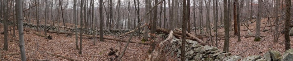
2:01 p.m.: The wall t-boned into another wall, with Barry Lakes in the background.

Stone walls on north side of Barry Lakes
I’m not sure how this strange turn in the tree developed.

Tree with odd shape
2:07 p.m.: My map showed a residential neighborhood in the middle of Wawayanda State Park, bordering the east end of Barry Lakes. The trick was to get to the east side of the lakes, when I was on the west side. The white-blazed footpath I was following turned into a white-blazed woods road. The map showed several woods roads on the west side. The map also showed that a path led between the two lakes and the neighborhood, and I thought it was the same path that I was following. However, whenever I came within sight of the lakes, I didn’t see a boundary between them or a place to cross.

Woods road north of Barry Lakes
2:29 p.m.: I decided that I was on a woods road that would take me about a mile past where I wanted to go, which was unacceptable. Therefore, I just bushwhacked, i.e., made my own path through the woods, by walking close to the perimeter of the lake. I decided that I had missed the place to cross in between the two lakes, and just continued to circle around the southern lake.

Barry Lakes
I soon came to the end of the lake and walked through a commercial parking lot to Wawayanda Road. I estimate that I had followed the white blazes 1.6 miles from the Old AT Vista to Wawayanda Road. I later learned that the AT had formerly been routed between the two lakes, along the white trail through the woods that I took, past the Old AT Vista, and then down the mountain following the now-unmaintained blue trail. It was rerouted in the 1960s to its current path. I am sure that some maintenance has been done on the “unmaintained trails” in the past 50 years, but perhaps they aren’t currently being maintained. In any event, it was easy for me to follow these trails, though as I noted the white-blazed trail did have many downed trees and branches.
2:42 p.m.: Wawayanda Road soon left the residential area and re-entered the park proper.

Park Entrance
Parts of Wawayanda Road were gravel, though later it was paved.

Wawayanda Road
2:59 p.m.: There were some nice wetlands within the park.

Wetlands
3:15 p.m.: After 2 miles on Wawayanda Road, I turned right onto the Black Eagle loop. I followed this 0.8 miles until it ended at the blue-blazed Hoeferlin trail.

Black Eagle Loop
3:29 p.m.: The Hoeferlin trail was where I had begun my hike, north of Wawayanda Road and the parking lot. Now I was on the same trail, but south of Wawayanda Road. I followed the trail another 0.75 miles back to my car.

Hoeferlin Trail
3:41 p.m.: I returned to my car, having hiked about 11.5 miles in 5-3/4 hours. The 2 mile per hour pace was a fast pace, helped in great part by the fact that most of the hiking was on level ground, and also that 2 miles was walking along Wawayanda Road.