I left Queens around 7:00 a.m. and arrived at the forest at around 9:15 a.m. This was another hike in which I was following in the footsteps of Daniel Chazin, who had submitted the hike to the NY-NJ Trail Conference website.
9:19 a.m.: At the parking lot, I pass the kiosk and enter the trailhead of the Alander Mountain Trail, at about 1700′ elevation.

Alander Mountain Trail
After crossing an open field, the trail entered a relatively dense woods.

Alander Mountain Trail
However, the trail soon popped out of the woods and crossed another field.

Alander Mountain Trail
9:31 a.m.: The trail then made a left turn and came to a brook, spanned by a footbridge. There had been significant rain and snowmelt recently, and the brook was therefore probably higher than usual. As a result, one end of the footbridge was under water.

Alander Mountain Trail
The water was clear enough:

Alander Mountain Trail
After 0.7 miles on the Alander Mountain Trail, I turned left (south) onto the Ashley Hill Trail. This trail ran parallel to the east of the Ashley Hill Brook.
9:54 a.m.: One complaint I had was that this trail (apparently an old woods road) was blocked in many spots by trees. I later learned that a number of trees had fallen during a winter storm about a month earlier, and the two park employees had been busy clearing other trails, but had not yet gotten to this one.

Ashley Hill Trail
9:58 a.m.: A blockage that required that I detour off the trail.

Storm damage
10:19 a.m.: At first, the Ashley Hill Brook was far below the trail, so that I could hear it, but I couldn’t see it. However, after a while, the brook ran right beside the trail, which was pleasant to behold.

Ashley Hill Brook
10:31 a.m.: More photos of the brook:

Ashley Hill Brook

Ashley Hill Brook

Ashley Hill Brook

Ashley Hill Brook
10:52 a.m.: There were also one or two spots where a stream crossed the trail, and I had to hop from rock to rock. My boots never got too wet, and the waterproofing was effective.

Stream crosses Ashley Hill Trail
10:57 a.m.: After about 1.6 miles, the trail turned left, departing from the woods road and becoming a footpath. A hunter apparently left behind his spent shotgun shell. The plastic and metal shell is not biodegradable.

Shotgun shell in the woods
11:26 a.m.: The footpath.

Ashley Hill Trail
In places, it was muddy or even submerged under an inch of water, which did not affect my boots.

Ashley Hill Trail
11:33 a.m.: After about 2.7 miles on the Ashley Hill Trail, I reached a monument on the border of Massachusetts and New York, right around 2100′ elevation. One side was engraved “Mass.” and one side “N.Y.”

Massachusetts-New York Border
After another 200′, the Ashley Hill Trail ended, and I turned left (east) onto the Mt. Frissell trail.
11:45 a.m.: After about another 0.1 miles, I encountered a second boundary marker. This marked the intersection of New York, Massachusetts and Connecticut. One side is engraved “N.Y.”, one side is engraved “Mass.”, and a third side is engraved “1898”. I don’t know why “Conn.” was not engraved on the fourth side.

Intersection of New York, Massachusetts, and Connecticut

Intersection of New York, Massachusetts, and Connecticut
11:57 a.m.: I continued following the Mt. Frissell trail east, as it began climbing..

Mt. Frissell Trail
Looking back toward the west, I was rewarded with a nice view.

View from Mt. Frissell Trail
12:04 p.m.: About 0.2 miles from the tri-state point, I reached the highest point in Connecticut, at 2379′. A couple—let’s call them “Chris and Liz”—was eating lunch there, so I only lingered long enough to snap a few shots toward the south, of Lake Riga, at 1752′ the highest lake in Connecticut.

Lake Riga
I continued another 200′ up the trail and had a broader view to the southeast:

Lake Riga, Connecticut
Speaking of the “High Point” of Connecticut, it is on the slope of Mt. Frissell. The peak of Mt. Frissell is in Massachusetts, however. Thus, Connecticut is unique as being the only state in which its highest point is not the peak of a land feature. I therefore continued east on the Mt. Frissell trail, heading for the peak.

Mt. Frissell Trail
12:14 p.m.: About 0.2 miles past the tri-state point, I reached a spot where the trail began descending sharply, and I realized that I must have passed the peak. Before returning to the west to look for it, I snapped a few photos toward the east.

Scenic view from Mt. Frissell Trail

Scenic view from Mt. Frissell Trail

Scenic view from Mt. Frissell Trail
12:19 p.m.: After backtracking 0.2 miles, I found the peak of Mt. Frissell, at 2454′. It is apparently marked by a cairn that is several feet off the trail. [Maybe there is a formal marker that I did not see.] A log book is also there, inside an aluminum box. [Of course, the highest point in Massachusetts is the peak of Mt. Greylock, at 3489′. I hiked there the previous season.]

Peak of Mt. Frissell
I recorded my name in the log.

Log book
The cover has an engraved nameplate “Optime Ambulate,” which Google Translate says is Latin for “walk very well.”

“Optime Ambulate”
12:31 p.m.: The couple who had been enjoying lunch at High Point, perhaps the “Chris and Liz” who had signed the log book before me, walked by toward the east, so I returned west to High Point. Here is a cairn to draw attention to a tiny brass marker with a vertical post in the center, marking the highest point in Connecticut. It’s not Everest, but it’s still got Florida beat.

Highest Point in Connecticut, on slope of Mt. Frissell
A close-up of the “high point” marker.

Highest Point in Connecticut, on slope of Mt. Frissell
I then continued east on the Mt. Frissell Trail, passing the intersection with the Ashley Hill Trail and continuing about another 0.3 miles past that, until it ended at the South Taconic Trail.
1:11 p.m.: The South Taconic Trail provided very nice views towards the east of the New York Taconic area.

View from South Taconic Trail
Toward the south, I had a view of Mt. Brace, at 2311′ the highest point in New York’s Dutchess County.

Mt. Brace, NY
A big cairn is on top, with a wind sock. (People hang glide off Mt. Brace.)

Closeup of peak of Mt. Brace, NY
1:19 p.m.: I then began hiking north on the South Taconic Trail.

South Taconic Trail
1:48 p.m.: I couldn’t really tell if this was meant to be a wall (for a boundary marker) or if people were just moving rocks out of the way for some reason.

South Taconic Trail
2:06 p.m.: I was able to get by this fallen tree without trouble. Only the Ashley Hill Trail had a problem with blockages.

South Taconic Trail
2:22 p.m.: The South Taconic Trail had dropped to about 1500′ elevation, running through the track of an old woods road, but here the white markers indicate a sharp turn to the right, away from the wood roads.

South Taconic Trail
2:23 p.m.: A sign confirmed that this was the path of the South Taconic Trail.

South Taconic Trail
2:34 p.m.: This became steep, climbing about 700′.

South Taconic Trail
3:00 p.m.: After about 3.3 miles on the South Taconic Trail, I finally made it back to open rocks with nice views.

Scenic view from South Taconic Trail
Turkey vultures soared on the thermal air currents.

Turkey vulture
3:03 p.m.: Self-portrait/shadow:

Shadow self-portrait
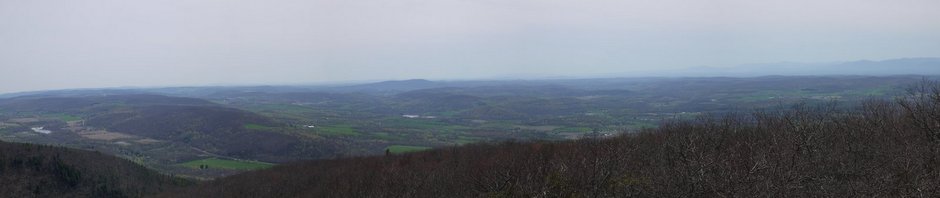
3:04 p.m.: Stitched panorama.

Panorama from South Taconic Trail
3:18 p.m.: I arrived at the peak of Alander Moutain, where the foundations of a fire tower remain. The peak is at 2239′.

Peak of Alander Mountain
Magnetic and triangulation geologic survey markers are present, at 2231′:

Peak of Alander Mountain

Peak of Alander Mountain
3:27 p.m.: I began my descent, heading east on the Alander Mountain Trail, heading back to the parking lot. This is a cabin that can be used by campers.

Cabin, Alander Mountain Trail
4:07 p.m.: Again, I’m not sure if this is a boundary marker or what purpose this wall served.

Alander Mountain Trail
4:20 p.m.: I reached a beautiful spot where the trail crossed a wide stream.

Wide stream, Alander Mountain Trail
Happily, a substantial bridge was provided for hikers.

Footbridge, Alander Mountain Trail

Stream, Alander Mountain Trail
4:41 p.m.: I returned to the bridge I had crossed at 9:31 a.m. One end was still underwater.

Alander Mountain Trail
I returned to the car around 4:52 p.m., having hiked about 12 miles in 7½ hours.
* * *
5:11 p.m.: On the drive to Mt. Washington State Forest, I had passed nearby Bash Bish Falls State Park, also in Massachusetts. I stopped off there on the way back. A trail ran about ¼ mile to the falls, dropping about 300′. Here is a makeshift bridge for crossing a wet area.

Trail at Bash Bish Falls State Park
5:22 p.m.: I made it down to Bash Bish Falls, a waterfall with a drop of about 80′, which is fed by most of the brooks and streams that I had seen in Mt. Washington State Forest.

Bash Bish Falls
I then climbed the 300′ trail back to my car, and drove home.