I was waiting for warmer weather to resume hiking, and finally decided that it was warm enough. I returned to Hudson Highlands State Park, having previously visited South Beacon Mountain and Breakneck Ridge. This day I decided to explore the area of the park near Nelsonville.
9:14 a.m.: I parked beside Little Stony Point and crossed highway 9D to the trailhead.

Washburn Trail
9:26 a.m.: I began to climb the white-blazed Washburn trail, and soon was rewarded with a nice view of the Hudson. In the foreground, one can see the tracks of the Metro-North Hudson Line. Across the Hudson is the southern part of Storm King State Park.

Hudson River from Washburn Trail
9:33 a.m.: A little higher up the trail, and one can see the town of Nelsonville (on the near side of Highway 9D), the town of Cold Spring (on the far side of Highway 9D), as well as Foundry Dock Park, the Constitution Marsh Sanctuary and Constitution Island, with West Point across the Hudson.

Nelsonville, Cold Spring, and Hudson River
After hiking around 1.1 miles and climbing to 1060′ elevation, I reached a four-way intersection and left the white trail, instead turning right (southeast) onto the yellow-blazed Undercliff trail. This trail was blazed in places with signs that featured an outline of a bull standing on a high spot (Bull Hill, known unofficially as Mt. Taurus), with words reading “Nelsonville Footpath / Hiker’s Hamlet.” This yellow trail descended to about 300′.
10:29 a.m.: A few boards from a hunting platform remain in this twinned tree.

Hunting platform
11:15 a.m.: After 1.0 mile, the yellow trail intersected the green-blazed Nelsonville Trail, a woods road, which I followed to the northeast. Right around that intersection I began seeing debris. First, while still on the yellow trail, I found some shattered concrete and bricks. Was there a home here at one time?

Debris on Nelsonville Trail
11:16 a.m.: Then, turning onto the green trail, I found an even worse garbage dump. It looks like part of an automobile (can anyone identify it?) and an old washing machine.

How can a trail be routed past a garbage dump?
11:20 a.m.: The green trail featured the same Nelsonville tags as the yellow trail. My East Hudson Trail Map 102 (2010 Edition) of the NY-NJ Trail Conference shows this area is not part of the Hudson Highlands State Park. [It is apparently part of the “Nelsonville Trail & Nature Preserve,” as I’ll soon learn.]

Nelsonville Trail & Nature Preserve, NY
11:22 a.m.: A nice stone wall.

Stone wall
11:24 a.m.: The green trail crossed Gatehouse Road, where there was a small parking area and kiosk. The kiosk featured a map and identified the areas as the Nelsonville Trail & Nature Preserve. This map disagreed with the NY/NJ Trail Conference map, which was a little disconcerting. Specifically, the NY/NJ Trail Conference map did not show the green trail intersecting Gatehouse Road, and as I was standing at that intersection, I would say that the NY/NJ Trail Conference map was wrong. I filed a report, and hopefully they can get to the bottom of this and fix the map as required.

Kiosk with map
11:35 a.m.: After spending a few minutes unsuccessfully trying to figure out why the two maps didn’t agree, I continued on the green trail, which soon crossed the Catskill Aqueduct. This house encloses an inverted siphon.

Inverted siphon house
11:37 a.m.: More litter on the trail (a “dime bag” decorated with marijuana leaves).

Dime bag litter
11:57 a.m.: The green trail began regaining the altitude that I had lost when I departed from the white trail to the yellow trail. Here, a water bar protects against erosion.

Water bar
12:49 p.m.: After 1.6 miles, the green trail dead-ended at the northeast end of the white trail. (I had started at the southwest end of the white trail.) I turned onto the white trail, climbing toward the top of Bull Hill (which has a peak at 1420′). The woods road of the green trailed continued on this part of the white trail, though it then began to switchback, while the blazed footpath took a straight line toward the top of Bull Hill. I followed the footpath instead of the switchbacks of the woods road.
, Hudson Highlands State Park, NY")
Climbing Bull Hill (Mt. Taurus)
I even found a few remnants of snow near the summit.
, Hudson Highlands State Park, NY")
Snow
12:53 p.m.: More views from the summit.
, Hudson Highlands State Park, NY")
View from summit
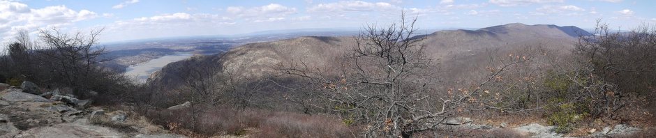
And a stitched panorama from the summit:
, Hudson Highlands State Park, NY")
View from summit
1:16 p.m.: There were also nice lookouts descending Bull Hill.
, Hudson Highlands State Park, NY")
Scenic view descending Bull Hill (Mt. Taurus)
After 0.9 miles on the white trail, I once again reached the intersection between the white trail and the yellow trail. This time I followed the yellow trail in the other direction, toward the northwest.
1:48 p.m.: The yellow trail reached a nice overlook of the Hudson, Nelsonville, Cold Spring, West Point, etc.

Scenic view of Nelsonville & Cold Spring
1:55 p.m.: At another overlook, about 0.4 miles after I had turned onto the yellow trail, I had a nice view toward the northwest. On the left side of the Hudson is Storm King Mountain. On the right side of the Hudson is Breakneck Point. One can also see the three tunnels: one carrying the lanes of Highway 9D, and two carrying the Metro-North Hudson Line.

Storm King Mountain, Hudson River, and Breakneck Ridge
The yellow trail then made a 90 degree turn toward the northeast, after about 0.4 miles crossing over the aqueduct. After another 0.4 miles, the yellow trail again turned back toward the northwest, and then after 0.5 miles reached Breakneck Brook and the intersection with the red-blazed Brook trail.
2:35 p.m.: At the intersection of the yellow and red trails, a bridge crossed Breakneck Brook. I remained on the southeast side of the Brook, and turned left (southwest) onto the red trail.

Bridge over Breakneck Brook
The brook:

Breakneck Brook
2:46 p.m.: The red trail ran along an old fence, with posts made of a concrete amalgam. Here, a tree has grown around the fence wire.

Tree growing around wire fence
2:50 p.m.: After about 0.2 miles, the red trail reached an intersection with the blue-blazed Cornish trail, and I turned left onto that trail. Remnants of the Edward J. Cornish Estate remained in this area. The Cornish family had purchased the land and buildings in 1917, though the property had been developed over the previous decade by a diamond merchant. There was a fine mansion, greenhouse, and dairy farm. Here is a screw-in gate pintle.

Screw-in Gate Pintle
Perhaps this cistern was associated with the estate.

Cistern
Here’s a stitched-panoramic view of the cistern.

Cistern
2:59 p.m.: The remains of the greenhouse.

Greenhouse
3:06 p.m.: The porte-cochère of the mansion.

Porte-cochère
A view through a window opening. The mansion was three stories, and some of the stone walls and chimneys remain. The mansion was apparently all but abandoned upon the death of the Cornishes in 1938, and was destroyed by fire in 1956.

Interior

Interior
3:19 p.m.: Almost at the end of my hike and back close to sea level, I had a nice view of the Hudson and Storm King Mountain. After 1.4 miles, the blue trail returned me to the start of my hike.

Hudson River and Storm King Mountain
3:37 p.m.: Since I had parked next to Little Stony Point, I decided to investigate it:

Little Stony Point
A pedestrian bridge crosses over the railroad. The point itself has a few very short trails and a tiny beach. I probably walked around 0.6 miles here.
So this was my first hike of the spring, and was about 8.5 miles.