Tuesday afternoon: I had mentioned that on the previous day’s three mile hike into the Bryce Amphitheater, I had developed a slight sunburn. At the camp store, I found a choice of two sunblocks and selected the Bull Frog SPF 50 Super Block Lotion Sunblock with Titanium Dioxide. Try saying that real fast. After applying this, I remembered that titanium dioxide is a white pigment, and I guess that’s what elderly people use when you see people on the beach with their noses painted white. This was only 7% titanium dioxide, so it wasn’t quite that bad, but it still left my skin looking much whiter than it should, so I wasn’t that fond of it. It was also so waterproof that a shower didn’t entirely remove it. This led me to buy a different brand of sunscreen, which was more pleasing.
After lunch on Tuesday, I drove south on the park road, past the Amphitheater and toward the overlooks I had seen in the morning. I stopped at Swamp Canyon, the trailhead for what was supposed to be a 4.3 mile hike, with a change in elevation of 800 feet.
I had printed out a little map and description from the park’s website, which I had with me, but for some reason I didn’t have the park brochure and map, which would have been very useful. I believe that I accidentally left it in the car. I had a description that read, “From the Swamp Canyon overlook, hikers can descend to either side of the prominence on a trail that will connect with the Under-the-Rim Trail and then return on the other side, making a loop.”
So I descended from the overlook, reaching a branch in the trail. To the left was a field with pronghorn in it. Unlike the deer I encountered, the pronghorn seemed more skittish, and even though they were quite far from me, seemed intent on keeping that great distance.

Pronghorn
To the left was the Sheep Creek Connecting Trail, and to the right was the Swamp Canyon Connecting Trail. This is all clear looking at the park brochure and map (which I didn’t have with me). Apparently the 4.3 mile hike was to go left on the Sheep Creek Connecting Trail, turn right when that trail ended at the Under-the-Rim Trail, and then turn right when the Under-the-Rim Trail intersected the Swamp Canyon Connecting Trail. (Or conversely, one could have gone right on the Swamp Canyon Connecting Trail, gone left when that trail ended at the Under-the-Rim Trail, and then gone left when that trail intersected the Sheep Creek Connecting Trail.)
Not realizing this, and with my printout not saying anything about a Sheep Creek Connecting Trail, and instead describing this as a Swamp Canyon hike, I turned right on the Swamp Canyon Connecting Trail. Then, when that trail ended at the Under-the-Rim Trail, I did not turn left on that trail, as the website had apparently intended, but instead I turned right . . .
But I’m getting ahead of myself.
About eight minutes later, the trail began descending to the bottom of the canyon floor. This was an interesting rock formation beside the trail. Note the hard cap rock on top.

Swamp Canyon Connecting Trail
This cap rock is apparently a different formulation of minerals that was deposited in some areas, so that while erosion allowed rain water to erode the surrounding rock, the cap protected this particular spot and prevented the rain from eroding the softer sandstone underneath. This is how the hoodoos and other formations in the park were created. It appeared that the trail continued straight ahead, and I stepped over a log and continued on, but a few feet later the trail appeared to vanish, and there was a very steep slope downward. I turned my attention back to formation in the photo above, and noticed a small hole with what appeared to be a nest of twigs and leaves. It was above my head level, but I used my camera to shoot a photo into the hole. There was nothing interesting there, though, so I don’t know if it was an old nest of birds or a squirrel or chipmunk.
I again considered the fact that the trail had appeared to vanish, and turned back toward the trail I had come from, thinking that I would abandon this hike. I then saw the continuation of the trail, as a switchback that I had not noticed as I descended the trail to this rock formation.
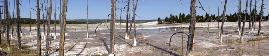
I continued on the trail, descending lower into the canyon. I quickly came to an area where there had been a forest fire.

Burned trees

Burned trees
One good thing about hiking on trails is that one avoids hazards that he might face walking in an area without a trail. One such hazard are tree stumps, which may eventually decompose to leave a deep hole in the ground. As I hiked through this burned area, I saw a few holes, close to the trail, where fire had consumed tree stumps, leaving deep pits in the ground.

Swamp Canyon Connecting Trail
Around this point, I reached the end of the Swamp Canyon Connecting Trail, and as discussed above, turned right onto the Under-the-Rim Trail. I should note that this entire time, I did not see a single person. This was a very different experience than on my other hikes on the trails in the park.

Burned trees
The damage from the forest fire continued. In some cases, trees still had pine needles, but they were a brownish color, and I wondered if the tree could survive or if it was already dead. I wondered how long ago this fire had occurred. I knew that I was not the first one to have entered the area since then, as there were other boot prints in the ashes.
The Under-the-Rim Trail then intersected the Whiteman Connecting Trail, which was not on my printout from the website, but which I realized was in the correct direction to lead to the top of the canyon and the road. I also knew that the Under-the-Rim Trail continued on for miles, to the southern end of the park. So I decided that the Whiteman Connecting Trail was the way to go.
The burned trees continued, and once or twice I thought I saw some smoke arising from the ashes, or felt some heat from it, and again wondered how recent the fire had been. I thought that the ashes were just being blown in the breeze. However, at one point I passed a hole in the ground, where a tree or at least its stump had formerly stood, and it was still smoking!

Smoking hole
The Whiteman Connecting Trail began moving upward, toward the canyon rim, and the scenery improved.

Whiteman Connecting Trail
Loud grasshoppers were flying around. I heard one and spotted him flying through the air near me, and then he landed. Can you spot him toward the bottom center of this photo? He blends in very well with the rocks and twigs. Even having watched him land, I had a hard time seeing him on the ground. I think it’s a band-winged grasshopper (Dissosteira spurcata Saussure).

Grasshopper
Climbing uphill is even better exercise than climbing downhill, but I finally made it to the top of the Whiteman Connecting Trail:

Whiteman Connecting Trail
I was becoming a little concerned about the length of the hike, especially as I didn’t have the park brochure and map that would have clearly showed me where I was going. I began wondering if I should turn back, but thought that I must be nearing the roadway, and so I continued on a few more minutes and the trail did indeed end at the road.
I knew that I was south of the Swamp Canyon overlook and where I had left my car, and a map at the head of the Whiteman Connecting Trail confirmed that I was 3.6 miles away from Swamp Canyon overlook. I knew that walking 3.6 miles on a paved (and relatively level) road would only take an hour and would not be too exerting, so that didn’t concern me.
Along the way, I stopped to photograph a bee enjoying some nectar.

Bee
Right around an hour later, I hiked to the Swamp Canyon overlook, the beginning of my hike. So instead of the 4.3 mile hike I had expected, I had about a 5.5 or 6 mile hike. At the overlook, I saw a posted notice about the forest fire, which I had not seen at the start of my hike. It had apparently begun five or six weeks earlier. It is amazing to me that a tree trunk was still burning weeks later. I did not report it, and don’t know if I was supposed to. It didn’t look like there was much fuel remaining to burn, so it was probably not much risk.

Bridge Fire news release

Bridge Fire facts
That evening, I went to a program at the visitor center at 8:00 pm, on the Night Sky at Bryce. I have previously mentioned that the air quality is usually excellent (when there aren’t forest fires at New Harmony), and as there aren’t many big cities around, there also isn’t much light pollution. Thus, there are usually grand views of the night sky at Bryce Canyon. The program was to discuss this, and afterwards to allow people to view the sky through telescopes.
I arrived at the visitor center a few minutes early. I heard one young woman talking to an older woman in Hebrew, and we made eye contact. During the day, when I was out on hikes, I wore a “boonie hat” to protect myself from the sun, but at night I was just wearing my yarmulke, so she no doubt realized that I identified her speech as Hebrew.
I fell asleep during the lecture, but can’t say whether that was due to having been hiking most of the day or whether the lecture wasn’t that interesting. After the lecture, I saw that the sky was still cloudy, whether with rain clouds or smoke clouds. I still felt tired, as well, so I decided to pass on the telescope viewing party and return to my campsite. I watched another Warehouse 13 video and then went to sleep.
The next morning, I packed up my tent and sleeping bag (well, I didn’t need to pack that well, since I wasn’t backpacking but rather “car camping.” So I threw the gear into the trunk of my car, without having to fold it and pack it too much.
On the way out of the park, I stopped at one last overlook that I had not yet visited, Fairyland Point:

Fairyland Point
I then bid farewell to Bryce Canyon, and drove to Zion National Park, about 75 miles away.
Next: Zion Canyon!